 LOGIN
LOGIN REGISTER
.png)


Case Study
Hydro-Meteorological Analysis of Flash Flood in Southern Jordan
Amer Maslamani1*, Mohammad Zeitoun2 and Ali Almagbile2
1Department of Geography, University of Jordan, Amman, Jordan
2Department of Geography, Yarmouk University, Irbid, Jordan
*Corresponding author: Amer Maslamani, Department of Geography, University of Jordan, Amman, Jordan, Tel: +962 777596918; E-mail: aam9160193@fgs.ju.edu.jo
Citation: Maslamani A, Zeitoun M, Almagbile A (2017) Hydro-Meteorological Analysis of Flash Flood in Southern Jordan. J Environ Sci Allied Res 2017: 32-38. doi:https://doi.org/10.29199/2637-7063/ESAR-101015
Received Date: 20 September, 2017; Accepted Date: 31 October, 2017; Published Date: 15 November, 2017
Abstract
In arid and semi-arid lands particularly in southern Jordan, several flash flood events have been recorded over the last 50 years. This has caused damage to life and infrastructure of urban areas, ruins the services and increases some health problems such as famine and disease. Thus, it is necessary to assess flash floods in terms of the causes (e.g., synoptic conditions), magnitude, and frequencies in order to construct sustainable plans that mitigate the influences of such environmental hazards. This study deals with analyzing hydro-meteorological parameters which cause flash flood in southern Jordan. Synoptic conditions associated with flash flood events were analyzed using meteorological maps for hPa level height over Eastern Mediterranean. Furthermore, morphometric parameters have been used to determine the potentiality of flash flood in sub-basin scale. In this regard, El-Shamy approach was used to classify every sub-basin into low, moderate or high probability of flood using the relationship between the morphometric parameters. Then GIS tools were employed to map the probability of flash flood for every sub-basin in the whole watershed. As a case study, Wadi Yutum (southern Jordan) watershed was selected to conduct the current study. The results achieved based on El-Shamy model have mapped every sub-basin into low, moderate or high potential of flash flood.
Keywords: Flash Floods; Hazards; Jordan; Morphometric Parameters; Wadi Yutum
Introduction
In arid and semi-arid areas, flash floods are considered one of the most devastating natural hazards in the world. Flooding typically occurs when intense rain falls over a short period of time and the water accumulates faster than soils can absorb it or rivers can carry it away. In most cases flood causes hazards which influences the infrastructure of urban areas, ruins the services and increase some health problems such as famine and disease. Thus, investigating the flash flood in terms of the magnitude and frequency is necessary to tackle the threat of flood and enhance urban planners achieving sustainable flood management policy.
Originally, flash flood especially in arid conditions has been determined using different morphmetric parameters [1,2]. These parameters such as bifurcation ratio, basin perimeter, Stream density, Stream frequency and circularity ratio have been employed to measure surface runoff and hence the probability of flood. The bifurcation ratio is defined as the ratio between the numbers of stream order to the number of the next order. Basin perimeter is the length of the line that outlined basin area. Stream density is the total length of all the streams in the basin to the area of the whole basin while stream frequency can be defined as the number of drainage segments per unit areas [3].
Low chances for flash flood occur if a catchment area includes high values of bifurcation Ratio (Rb). This is because a huge amount of water infiltrates under the surface and hence groundwater reservoirs are potentially enriched. However, when a basin has high stream Density (D) as well as high stream Frequency (F), chances for flash flood are high. In this case, the probability of permeability is low and hence low amount of water contributes to groundwater reservoirs [1]. Circularity ratio is also influences the flow and sediment as such a large value of circularity ratio yields low velocity of flow.
Besides morphometric parameters, other parameters such as soil properties, topographic indices and land use management are also influences flash flood in terms of magnitude and frequency. For instance, it has been approved that generation of runoff increases as a corresponding to modern land management [4]. In addition, soil structure degradation contributes on runoff generation. Management practices which cause soil compaction at the surface reduce the infiltration capacity of the soil and can lead to infiltration-excess runoff [5]. Moreover, Topographic Wetness Index (TWI) which is highly correlated with several soil attributes such as horizon depth, silt percentage, organic matter content has a great impact on runoff generation and hence flash flood. As an instance of that is the aspect and the degree of the slope influence the direction of the flow paths.
In this study, analysis of the flash flood in southern Jordan will be investigated based on hydro metrological parameters. Therefore, synoptic conditions associated with the flash flood will be analyzed. This allows understanding the seasons of flash flood, frequency and magnitude. Then the probability of flash flood will be highlighted using three domains extracted from El-Shamy model. Thus, sub-basin can be classified into low, moderate or high potential of flash flood. This will enhance the decision makers to manage and monitor land use practices in either basin or sub-basin scale.
Related Work
Flood hazards mitigation has been investigated in different approaches and engineering programs. For example, Public Perception of Rivers and Flood Defense Project and the European Union-funded EURO flood Project investigated mitigation of flood hazards from different point of views. This is because flood hazards is multidimensional problem which needs collaborative research work [6].
Many research programs have been conducted to mitigate the risk associated with flood in either government or individual’s scales. In government scale, Flood Risk Management Research Consortium (FRMRC) and Flood Risk from Extreme Events (FREE) are examples of research programs conducted in UK for investigation the influence of land use practices on flood. Another example is Utilities Sustainable Catchment Management program focused on flood mitigation under different land use practices in Upper Hodder (UK) catchment [7]. Regarding individual research studies, O’Connell et al., [8] investigated the influence of land use management on the floods. The study reviewed the national and international literature for evidence of land use practices on the floods and found that due to the modern farm management practices such as increased stocking densities on grassland, local runoff increases and hence the probability of flood is high. Beven et al., [9] evaluated the data from UK catchment in which significant rural land use change has been observed and concluded that climate variability and uncertainty in data prevented any signals being identified.
Regarding arid and semi-arid regions and catchments, a number of research studies have focused on estimating the influence of topographic and hydromorphmetric parameters on flash flood. These studies (e.g., Patton [10], Farhan [11], El-Shamy [12], Youssef et al., [13]) conducted research on semi-arid watershed and assessed the hydromorphmetric parameters that cause flash flood. Abdel-Lattif et al., [14] employed Digital Elevation Model (DEM) to analyze morphometric parameters and its relation to the flash flood in Wadi Sudr and Wadi Wardan, Gulf of Suez, Egypt. Abdalla et al., [1] employed El-Shamy’s model to assess the hydro morphometric parameters on flash flood in dryland watersheds in the southern Red Sea coast of Egypt. Similar study conducted by Abduladheem et al., [15] focused on estimation flood hazards impacts on desert roads in south Sinai, Egypt using GIS-based morphometric analysis. In Jordan, case study was undertaken by Farhan and Anbar [16] to estimate the impacts of May 2014 flash flood disaster in Aqaba area. Similarly, Al-Qudah [17] estimated flash flood discharge in southern Jordan. The study highlighted the synoptic conditions associated with the flood (flood 2006) and then HEC-RAS software was utilized to estimate the flood amount. Assessment of Flood Hazards of Jeddah Area has been studied by Al-Saud [18]. He employed high resolution images extracted from IKONOS satellite to assess the influence of flash flood disaster on Jeddah area.
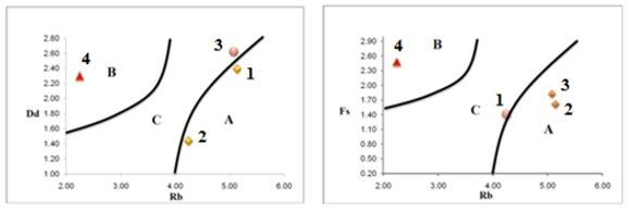
Regarding the model of the flood risk assessment, several models have been created to estimate flash flood risk and predict the consequences [19]. One of these models is El-Shamy model which explains the relation between the stream Frequency (F), the Bifurcation Ratio (Rb) and stream Density (D). This model contains three domains namely A, B and C. Domain (A) reflects the relationship between low stream Frequency (F), low stream density (D) and high bifurcation Ratio (Rb). In this domain type, low flood opportunities occur and good chances to recharge shallow aquifer. On the other hand, domain (B) represents the highest probability of flood and the least groundwater potentiality due to low bifurcation Ratio (Rb), high stream Density (D), and high stream frequency (F). Domain (C) includes all basins in between domain (A) and domain (B) and indicates moderate probability of flood and groundwater recharge [1]. Some studies however constructed models using GIS-based morphometric analysis. Youssef et al., [20] proposed an approach to estimate levels of flash flood risk and compared it with El-Shamy’s model. Likewise, Zhong and Lu Gui [21] constructed a flash flood model based on GIS tools and estimated the potential risk associated with flood. They concluded that the proposed model was effective particularly in sub-basin watersheds.
Synoptic Conditions Associated with Flash Flood in Southeastern Mediterranean
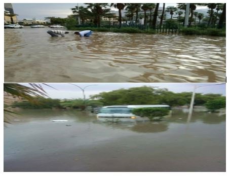
Over the past 50 years, several flash flood events have been recorded in southern Jordan particularly in Aqaba region. For instance, severe flood events have been found in 1963, 2006, 2010 and 2016 (Figure 1). As a result, analyzing the hydro-meteorological databases that determine the main reasons for flash flood in arid and semi-arid areas particularly in the east Mediterranean has been taken attention by many investigations (e.g., Dayan and Abramski [22], Inbar [23], Schick and Lekach [24], Kahana et al., [25]). According to these studies, synoptic conditions which are mainly responsible on flash flood in the east Mediterranean region such as Jordan, Egypt and Israel can be classified into four synoptic types; these are: active Red Sea Trough (RST), Mediterranean cyclone over Syria, jet stream, and Sharav Cyclone (SC).
|
Figure 1: Example of flash flood in Aqaba Area, Jordan, 27-28/10/2016. |
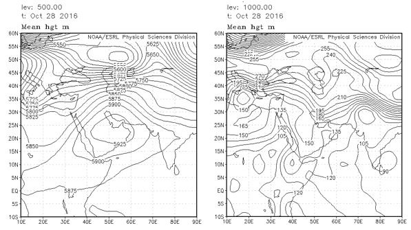
The active Red Sea Trough (RST) is responsible on around 38% of flash flood on east Mediterranean region [25]. This synoptic type is defined as a surface low-pressure trough which begins in the Southern Red Sea and extends towards the Eastern Mediterranean (EM) [26]. The original point of the RST is Sudan Monsoon Low, a part of a large-scale subtropical/equatorial low-pressure thermal system. Due to topographic and thermal forcing factors over the Red Sea region, the RST extended towards northward. In most cases the Red Sea Trough (RST) occurs in spring and autumn and it may also affect the region in winter and disappear in summer [25,27,28]. Figure 2 illustrates Red Sea Trough for 500 hPa and 1000 hPa over EM on 28 October 2016.
|
Figure 2: The two Sea-Level Pressure (SLP) charts represent: The Red Sea Trough for the 500 hPa level height with contour interval of 5 m (left) and the Red Sea Trough for the 1000 hPa level height with contour interval of 25 m (right) with an axis east of the EM coastline, Actual maps at the centers of their clusters from the NOAA-CIRES reanalysis on 28 October 2016. |
Generally, the RST is associated with hot and dry weather conditions over the eastern Mediterranean region, thereby southern Jordan are greatly influenced. These weather conditions are caused by the east and southeasterly flows at the lower atmosphere. In some rare cases, the RST is accompanied by an upper trough extending from the north over the whole region of the eastern Mediterranean. Thus, upward motion and unstable conditions occur and hence several convective storms cause heavy showers and thunderstorms, mainly at the southern part of Jordan [25].
Another reason that causes severe floods in southern Jordan is related to the surface cyclone centered over Syria [25]. This defined as a trough extends southeastward toward south Mediterranean. According to a study conducted by Kahana et al., [25], Mediterranean cyclone over Syria (also known Syrian low) is responsible on around 33% of flood events in Negev. Because of this synoptic type, the number of major flood producing storm was one in October, one in November, seven in December, three in February, two in March and two in April [29].
On the other hand, Jet stream is cause very few major floods in the Mediterranean region. This synoptic type was found due to the existence of a trough in the Subtropical Jet (STJ) over northeastern Africa combined with a ridge over Syria. Sharav Cyclone (SC) Alpert and Ziv [30] is defined as a shallow frontal cyclone that moves eastward along the northern coast of Africa. This cyclone is responsible on some major floods in the regions. This cyclone type occurs mainly in the spring season and causes rain showers and thunderstorms over North Africa.
Case Study: Flash Flood in Wadi Yutum
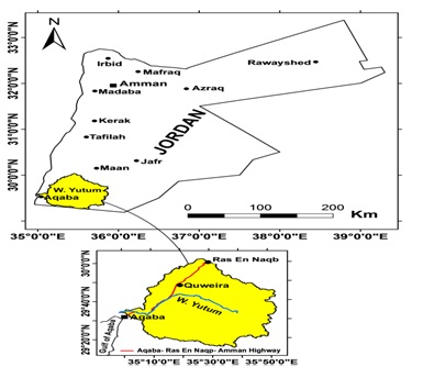
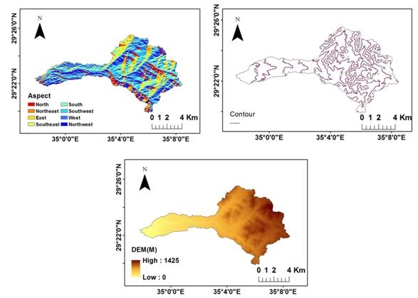
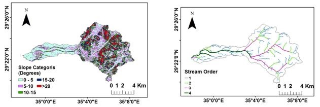
The location of Wadi Yutum in southern Jordan determines the harsh climatic and hydrologic conditions in the area. As part of Aqaba area, Wadi Yutum lies between 29.15 N to 30.01 N latitudes and 34.58 E to 35.52 E longitudes (Figure 3). As shown in figure 4 which shows the Digital Elevation Model (DEM), aspects, and contour lines, the elevation of Wadi Yutum is gradually increases from 0 meter in Aqaba to approximately 1425 meter where the highest elevation is found near the summit of Jabal Rum. Wadi Yutum is deemed as the main Wadi in Aqaba region and it mainly contributes to the flash flood in tadihe region. It can be seen in figure 5 that the slope of the Wadi ranges from 0 degree to around 20 degrees. Therefore, this W has a significant contribution of flash flood in Aqaba regions. Moreover, four stream orders have been found in this Wadi.
|
Figure 3: The location of Wadi Yutum in Jordan (Farhan and Anaba [2]). |
|
Figure 4: Aspects (top left) contour lines (top right) and DEM (bottom) of Wadi Yutum (Jordan). |
Vegetation and agricultural activities are very rare in the area and thus a huge amount of precipitation is divided into runoff and groundwater recharge [31]. This is because of the topographic characteristics in the whole region which consists of igneous rocks sequence (pre-Cambrian) [2,32]. The granite horst/inselberg which is consisted from aplite-granite, granodiorite, and quartzdiorite can be found at the base of sandstone inselberg. One can note that, the topographic characteristics are varied in the regions due to different factors such as the variation of composition of granite and the magnitude of weathering.
|
Figure 5: Slope categories (top left) and stream order (top right) of Wadi Yutum (Jordan). |
Methodology
In order to calculate the morphometric parameters, different topographic maps with a scale of 1: 50,000 were used. In addition, ASTER Digital Elevation Model available online were also utilised to calculate different morphometric parameters. After extracting the topographical characteristics of the Wadi, they were used as inputs in ArcGIS 10.3 and processed using spatial analysis toolbox. The output such as drainage networks, slope categories and elevation were then used as inputs in Arc Hydro toolbox to delineate the watersheds and stream networks of the study area.
After processing the topographic dataset, flash flood risk level was estimated using El-Shamy approach. In this approach the relationship between bifurcation ratio and drainage density, as well as the relationship between bifurcation ratio and stream frequency are determined. The density of drainage reflects the topographic and hydrologic conditions such as potentiality of runoff, infiltration capacity of surface materials, climatic conditions, and land use practices in the watershed [2]. Therefore, if a basin has low values of drainage density, infiltration rate will be high and thus the runoff potential is very low. On the other hand, the values the potentiality of runoff increases when a basin has high stream frequency. This is due to the fact that the infiltration rate is very low. When implementing the abovementioned relationships on each sub-basin, estimation of flash flood risk can be estimated.
Results Analysis
Using El-Shamy Model which based on the relationship between some morphometric parameters, the potentials of flash flood and groundwater aquifers recharge were estimated. According to figure 6, Wadi Yutum sub-basins have been categorized into high, moderate and low. As can be seen in figure 6 (left) which shows the relationship between bifurcation and stream frequency, sub-basin number four has the highest flooding chances comparing with other sub-basins (1,2 and 3). Similar situation can be found in case of the relationship between bifurcation and drainage density. In case of the relationship between bifurcation and stream frequency, sub-basin number one has moderate flood risk whereas sub-basins two and three have low chances of flood risk. However, opposite situation can be seen in case of the relationship between bifurcation and drainage density. Both of sub-basins one and two are categorized as low flood risk while sub-basin three has moderate chance of flood risk.
One might note that, low charge conditions of shallow aquifer in sub-basin four, whereas sub-basin one, two and three has the highest possibility of ground water recharge. This is due to the fact that limited flooding opportunities are found in those sub-basins comparing with sub-basin four. Consequently, sub-basin four should be supported by water gathering systems such as dam for increasing recharge conditions and reducing flash floods possibilities. This would mitigate the movement of water runoff, and facilitate downward water infiltration from the flood plains.
|
Figure 6: Flash flood risk assessment according to El-Shamy model relationship between bifurcation and stream frequency (left) and relationship between bifurcation and drainage density (right). |
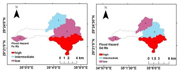
Figure 7 shows the three domains of flood risk for each sub-basin based El-Shamy model. It is clear that in case of the relationship between Dd and Rb, high and moderate probability of flood occurs in sub-basin number 4 and 3 respectively. Low probability of flood is found in sub-basins 1 and 2. In case of the relationship between Fs and Rb the flood risk situation are interchangeably with the previous relationship case (Dd and Rb). It is notable that sub-basins 1 and 2 have low probability of flood while sub-basin 3 has moderate flood susceptibility. One can note that sub-basin 4 was classified as the highest probability of flood in both relationship scenarios.
|
Domains A: low flood B: high flood C: intermediate flood Figure 7: The relationship between Bifurcation Ratio (Rb) and Drainage Density (Dd) (left) and Bifurcation Ratio (Rb) and stream Frequency (Fs) (right) based on El-Shamy’s domains. |
Conclusion Remarks
This study deals with analyzing the hydro meteorological parameters that cause flash flood in arid and semi-arid lands in southern Jordan. Synoptic conditions associated with major flood in southern Jordan have been analyzed. The results of the synoptic conditions that cause major flood events in the study area have determined. These conditions were active Red Sea Trough (RST), cyclone centered over Syria, jet stream and Sharav Cyclone. Besides, morphometric parameters were used to determine the potentiality of flood in sub-basin scale. The relationship between these parameters has been extracted to classify each sub-basin into low, moderate or high potential of flash flood. This has been done using El-Shamy model which determine sub-basin into three domains (A, B or C). Domain A indicates that the sub-basins have low chances of flood and hence the probability of groundwater recharge is high, Whereas, domain C illustrates that the chances of flash flood is high and thus dams should be built to mitigate floods. Domain B comes in between domain A and C and indicates that there is a chance of groundwater recharge a long with moderate chances of flood.
Based on El-Shamy approach, the results show that one sub-basin (sub-basin number 4) has high potential of flood, one sub-basin has moderate chances of flood and two sub-basins have low potential of floods. Therefore, this study recommends avoiding huge concrete buildings in the sub-basins which has high chances of flood while sub-basins with low flood chances can be exploited in agricultural activities. Future research requires more analysis of flash flood with focusing on the relationship between hydro-metrological parameters and land use in catchment scale.
References
- Abdalla F, El Shamy I, Bamousa A, Mansour A, Mohamed A, et al. (2014) Flash Floods and Groundwater Recharge Potentials in Arid Land Alluvial Basins, Southern Red Sea Coast, Egypt. International Journal of Geosciences 5: 971-982.
- Farhan Y, Anaba O (2016) Flash Flood Risk Estimation of Wadi Yutum (Southern Jordan) Watershed Using GIS Based Morphometric Analysis and Remote Sensing Techniques. Open Journal of Modern Hydrology 6: 79-100.
- Horton R (1945) Erosional Development of Streams and Their Drainage Basins; Hydrophysical Approach to Quantitative Morphology. Geological Society of America Bulletin 56: 275-370.
- O’Donnell G, Ewen J, O’Connell PE (2011) Sensitivity maps for impacts of land management on an extreme flood in the Hodder catchment, UK. Physics and Chemistry of the Earth, Parts A/B/C 36: 630-637.
- O’Connell PE, Ewen J, O’Donnell G, Quinn P (2007) Is there a link between land-use management and flooding? Hydrol Earth Syst Sci 11: 96-107.
- Fordham M (1999) Participatory planning for flood mitigation: models and approaches. Australian Journal of Emergency and Management, The, 13: 27-34 .
- McIntyre N, Ballard C, Bulygina N, Frogbrook Z, Cluckie I, et al. (2012) The potential for reducing flood risk through changes to rural land management: outcomes from the Flood Risk Management Research Consortium. In: BHS 11th National Symposium, Hydrology for a changing world, University of Aberdeen, Scotland.
- O’Connell PE, Beven KJ, Carney JN, Clements RO, Ewen J, et al. (2004) Review of impacts of rural land use and management on flood generation: Impact Study Report. Department for Environment, Food and Rural Affairs.
- Beven K, Young P, Romanowicz R, O’Connell E, Ewen J, et al. (2008) Analysis of historical data sets to look for impacts of land use and management change on flood generation. Joint Defra/EA Flood and Coastal Erosion Risk Management R&D Programme, London, UK.
- Patton PC (1988) Drainage Basin Morphometry and Floods. In: Baker V, Kochel R, Patton P (eds.). Flood Geomorphology. Wiley, New York, USA. Page No: 51-65.
- Farhan Y (1989) Urban Planning and the Evaluation of Flood Hazard in Arid Lands of Jordan: Aqaba Case Study. In: Farhan Y, Beheiry S, Abu Satat M (eds.). Geomorphological Studies on Southern Jordan. Publication of the University of Jordan, Jordan. Page No: 181-206.
- El Shamy I (1992) Recent Recharge and Flash Flooding Opportunities in the Eastern Desert, Egypt. Annuals of Geological Survey of Egypt 18: 323-334.
- Youssef AM, Pradhan B, Hassan AM (2011) Flash Flood Risk Estimation Along the St. Katherine Road, Southern Sinai, Egypt Using GIS Based Morphometry and Satellite Imagery. Environmental Earth Sciences 62: 611-623.
- Abdel-Lattif A, Sherief Y (2012) Morphometric Analysis and Flash Floods of Wadi Sudr and Wadi Wardan, Gulf of Suez, Egypt: Using Digital Elevation Model. Arabian Journal of Geosciences 5: 181-195.
- Abduladheem A, Elmewafey M, Beshr A, Elnaggar AA (2015) Using GIS Based Morphometry Estimation of Flood Hazard Impacts on Desert Roads in South Sinai, Egypt. International Journal of Scientific and Engineering Research 6: 1593-1599.
- Farhan Y, Anbar A (2014) Fragile Landscape: Impact and Consequences of May 2014 Flash-Flood Disaster in the Aqaba Area, Southern Jordan. Research Journal of Environmental and Earth Sciences 6: 451-465.
- Al-Qudah K (2011) Floods as Water Resource and As a Hazard in Arid Regions: a Case Study in Southern Jordan. Jordan Journal of Civil Engineering 5: 1-14.
- Al-Saud M (2010) Assessment of Flood Hazard of Jeddah Area 2009, Saudi Arabia. Journal of Water Resource and Protection 2: 839-847.
- Tsakiris G (2014) Flood risk assessment: concepts, modelling, applications. Nat Hazards Earth Syst Sci 14: 1361-1369.
- Youssef AM, Pradhan B, Gaberr AFD, Buchroithner MF (2009) Geomorphological Hazard Analysis along the Egyptian Red Sea Coast between Safaga and Quseir. Nat Hazards Earth Syst Sci 9: 751-766.
- Zhong L, Lu Gui H (2012) Potential flash flood risk assessment model and its application in Sub-basin. World Automation Congress (WAC), 24-28 June 2012, IEEE, Puerto Vallarta, Mexico.
- Dayan U, Abramski R (1983) Heavy rain in the Middle East related to unusual Jet Stream properties. Bulletin of the American Meteorological Society 64: 1138-1140.
- Inbar M (1987) Effects of a high magnitude flood in a Mediterranean climate: a case study in the Jordan River basin. In: Mayer L, Nash D (eds.). Catastrophic Flooding. Allen and Unwin, Boston, London. Page No: 333-353.
- Schick AP, Lekach J (1987) A high magnitude flood in the Sinai desert. In: Mayer L, Nash D (eds.). Catastrophic Flooding. “Binghamton” symposia in geomorphology. Allen and Unwin, Boston, London. Page No: 381-410.
- Kahana R, Ziv B, Enzel Y, Dayan U (2002) Synoptic Climatology of Major Floods in the Negev Desert, Israel. Int J Climatol 22: 867-882.
- Ashbel D (1938) Great floods in Sinai Peninsula, Palestine, Syria and the Syrian Desert, and the influence of the Red Sea on their formation. Quarterly Journal of the Royal Meteorological Society 64: 635-639.
- Dayan U, Sharon D (1980) Meteorological parameters discriminating between widespread and spotty storms in the Negev. Israel Journal of Earth Sciences 29: 253-256.
- Sharon D, Kutiel H (1986) The distribution of rainfall intensity in Israel, its regional and seasonal variations and its climatological evaluation. Int J Climatol 6: 277-291.
- Kahana R, Ziv B, Dayan U, Enzel Y (2004) Atmospheric predictors for major floods in the Negev Desert, Israel. Int J Climatol 24: 1137-1147.
- Alpert P, Ziv B (1989) The Sharav cyclone: observations and some theoretical considerations. Journal of Geophysical Research 94: 18495-18514.
- Aqaba Region Authority (1987) Flood Analysis Report for the Aqaba Basin: Wadi Flood Control Study. Amman, Jordan.
- Bender F (1974) Geology of Jordan. Gebruder Borntraeger Verlagsbuchhandlung, Berlin.